
“Historical Cemetery, East of Carr’s Pond Road, 36 burials with 0 inscriptions, On Macera’s place (the old Straight Farm). The Straight cemetery is all fieldstones. The Spencers buried 4 people on the west side of this cemetery. … Henry Straight’s family and others are buried here…”
–database cemetery description–
Graves Registration Committee, July 1956
Rhode Island Graves Registration Committee
July 1956
Showing Location of Historical Cemeteries
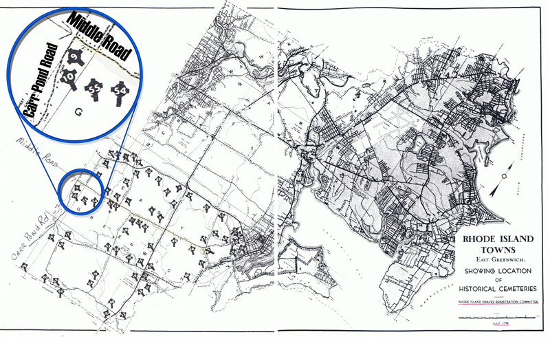
Rhode Island Towns
East Greenwich
The above map shows the locations of the known historical cemeteries in East Greenwich, Rhode Island in July of 1956. The No.10 cemetery is south of Middle Road and east of Carr’s Pond Road. Numerous historical maps show this was originally Henry Straight’s land and then William Spencer’s land and, therefore, the location of the Straight (Over-back) Cemetery. On this 1956 map, the black cross on the location of the cemetery ground easily locates all known East Greenwich historical cemeteries. At the center of the black cross is a white number, which represent the number of that particular historical cemetery. On the above map, the No.10 historical cemetery is south of Middle Road and east of Carr’s Pond Road.
Another pertinent fact is that the No.10 historical cemetery is just south of the No.9 Spencer Family historical cemetery– with its gated entrance and walled location– on the south side of Middle Road.
This East Greenwich Historical Cemetery No. 9 is where seven generations of William and Mary (nee Manchester) Spencer’s descendents are buried. Although William and Mary (nee Manchester) Spencer are buried in No.10, their descendants — seven (7) following generations– are buried in No.9. The only exception is William and Mary’s first son, Richard, and first daughter, Elizabeth, are buried in the No.10 cemetery with their parents. The mother and father are in the first row and the two children are buried in the second row as was the custom in that day. If a third generation of Spencers had been buried there in the No.10, the third generation would have been in the third row and so on.
Although the “owners” of Rhode Island historical cemeteries are the descendents, no further descendents–current day or future descendents–will be buried in an historical cemetery. Historical cemeteries are of a colonial period and revered because of that time period in our history. It would be inappropriate or misleading to continue burials in historical cemeteries today or in the future.
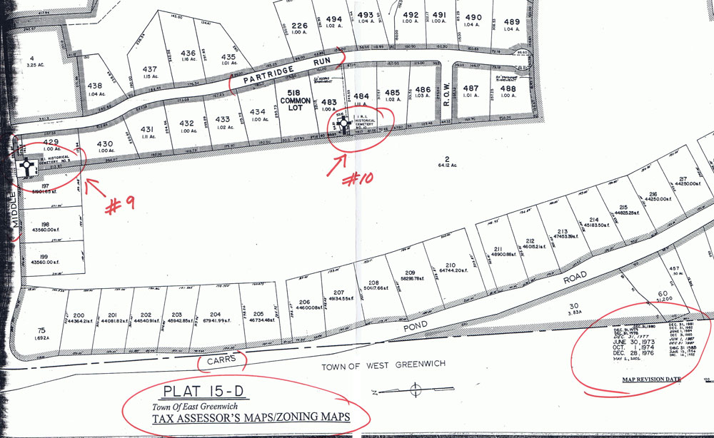
Plat 15-D Tax Assessor’s Maps/Zoning Maps–revision dates from 1973-2001–at the East Greenwich Town Hall building. E.G. historical cemetery No.10 (the Straight cemetery) is 1,383 feet to the south of E.G. historical cemetery No.9 where seven generations of William and Mary (née Manchester) Spencer’s descendants are buried.
TAX ASSESSOR’S MAPS/ZONING MAPS
Tax Assessor’s Maps/Zoning Maps Plat 15-D (Town of East Greenwich) shows location of East Greenwich Historical Cemetery No.10 as south of Middle Road and to the east of Carr’s Pond Road. All tax assessor’s maps/zoning maps show historical cemeteries with a large black cross (white circle at the center of the cross) enclosed within a rectangular marked area. Locating known historical cemeteries in East Greenwich is therefore very easy to find by looking at these maps in the East Greenwich Town Hall. (Note that the No.10 Historical Cemetery is just south of the No.9 Historical Cemetery on this map.)
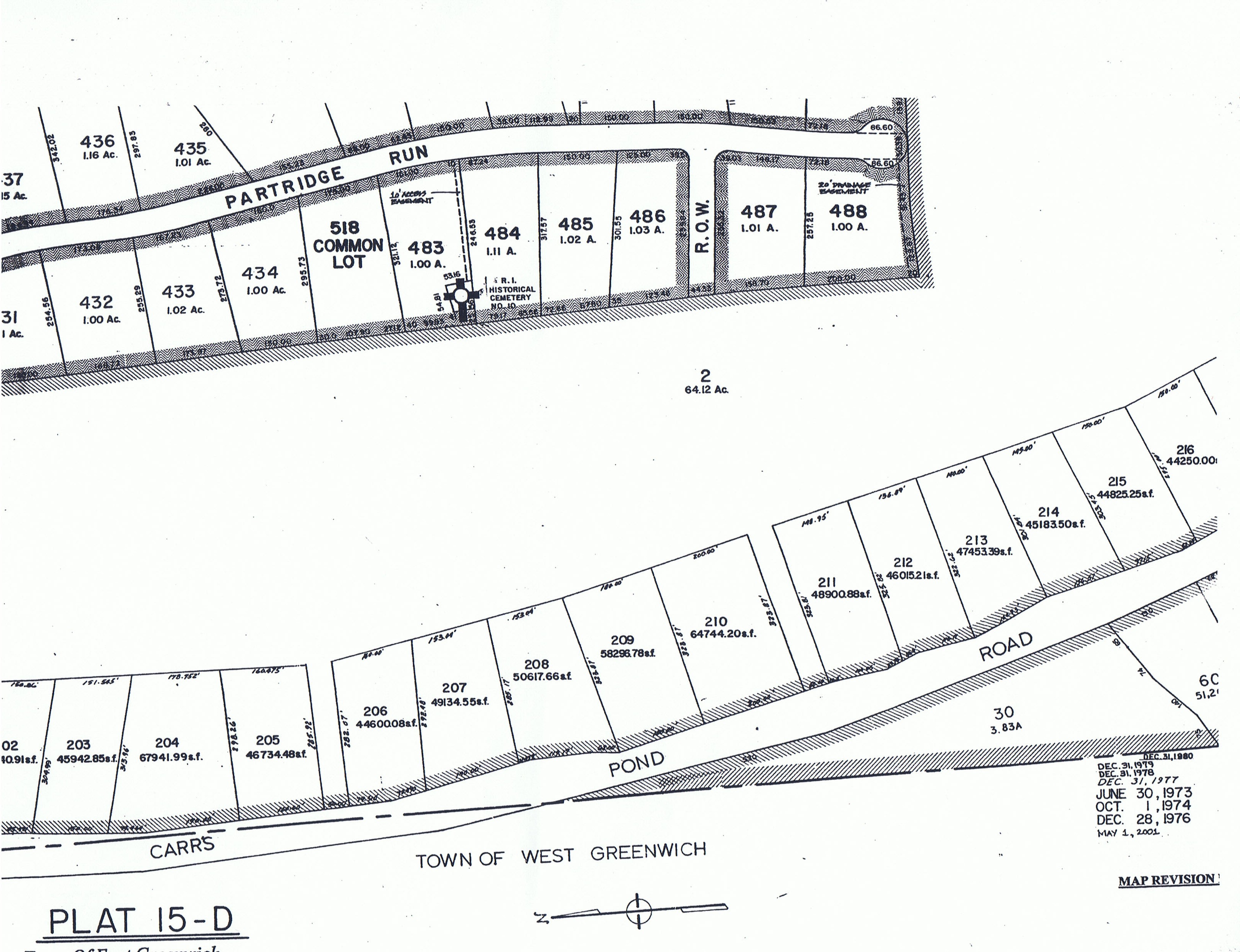
Enlargement of the section of Plat 15-D Tax Assessor’s Map/Zoning Map showing the proximity and direction of RI HISTORICAL CEMETERY#10 from Carr’s Pond Road.
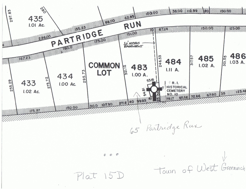
Enlargement of the section of Plat-D Tax Assessor’s map/zoning map–revision dates from 1973-2001–showing the Straight (aka Over-back) cemetery location as RI HISTORICAL CEMETERY #10.