
In the 1990’s the sturdy Rhode Island colonial old stone wall became the western boundary line for the planners of the subdivision, Pheasant Ridge-Phase II, on Partridge Run in East Greenwich. This is the stone wall that connects the two cemeteries, the Straight/Spencer family cemetery and the Spencer family cemetery, where Spencers are buried. The newer cemetery is on Middle Road and the older one is 1,383 feet to the south of Middle Road with its planned 10 foot easement entrance from Partridge Run. This cemetery connecting stone wall continues to the south of the two burial grounds and runs approximately parallel to Partridge Run.

New Home Builders Plan for Pheasant Ridge: Owner & Developer, Engineer, Survey & Plan Conformity to Standards, Zoning Data, Plat Areas, Curve Table, Legend (Five Notes)
New Home Builders Plan for Pheasant Ridge: Owner & Developer, Engineer, Survey & Plan Conformity to Standards, Zoning Data, Plat Areas, Curve Table, Legend (Five Notes)
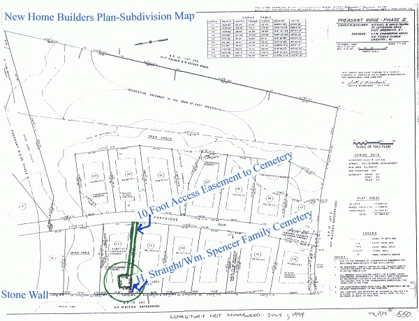
According to the above map, the developer/owner of the land around the HenryStraight/WilliamSpencer Historical Cemetery when the land was under development was Michael & Amico Truppa, 25 Jefferson Drive, East Greenwich, R.I. The engineer was SFM Engineering Assoc. 410 Tiogue Avenue, Coventry,R.I. Above is the information they had on the zoning data, plat areas, legend…of Phase II of PHEASANT RIDGE when they were developing that area around the Straight Cemetery. “This survey and plan conform to a class 1 standard as adopted by the RI Board of Registration for professional land Surveyors” by Scott F. Moorehead”. The 5th note (lower right hand corner of above map) reads “THE CEMETERY WAS RESERVED BY RICHARD A., WILLIAM J.B., & ALFRED E. SPENCER IN A DEED DATED APRIL 10,1922 RECORDED AT BOOK 25 PAGE 540”.

Enlargement of Builder’s map showing the placement of the historical cemetery on the land to be developed

TEN FOOT ACCESS EASEMENT TO CEMETERY FROM PARTRIDGE RUN; CEMETERY NOT PART OF LOT 11 OR 12; CEMETERY ON THE EAST SIDE OF THE WEST STONE WALL.
The last decade of the twentieth century is when the land around the Straight Cemetery is changing from the pristine fields of rocks, trees… on the east side of the property’s western boundary original stone wall. The above subdivision plans show the Straight Cemetery clearly marked on the builder’s plans –“CEMETERY (NOT PART OF LOT 11 OR 12) …10′ ACCESS EASEMENT TO CEMETERY…246.53′ from street to entrance of cemetery…” Five (5) notes pertaining to the land to be developed and subdivided are on the lower right hand corner of the Builder’s map plan. The 5th note reads “THE CEMETERY WAS RESERVED BY RICHARD A., WILLIAM J.B., & ALFRED E. SPENCER IN A DEED DATED APRIL 10,1922 RECORDED AT BOOK 25 PAGE 540.

Notes on Builder’s Survey: 5th note reads “THE CEMETERY WAS RESERVED BY RICHARD A., WILLIAM J.B., & ALFRED E. SPENCER IN A DEED DATED APRIL 10,1922 RECORDED AT BOOK 25 PAGE 540.
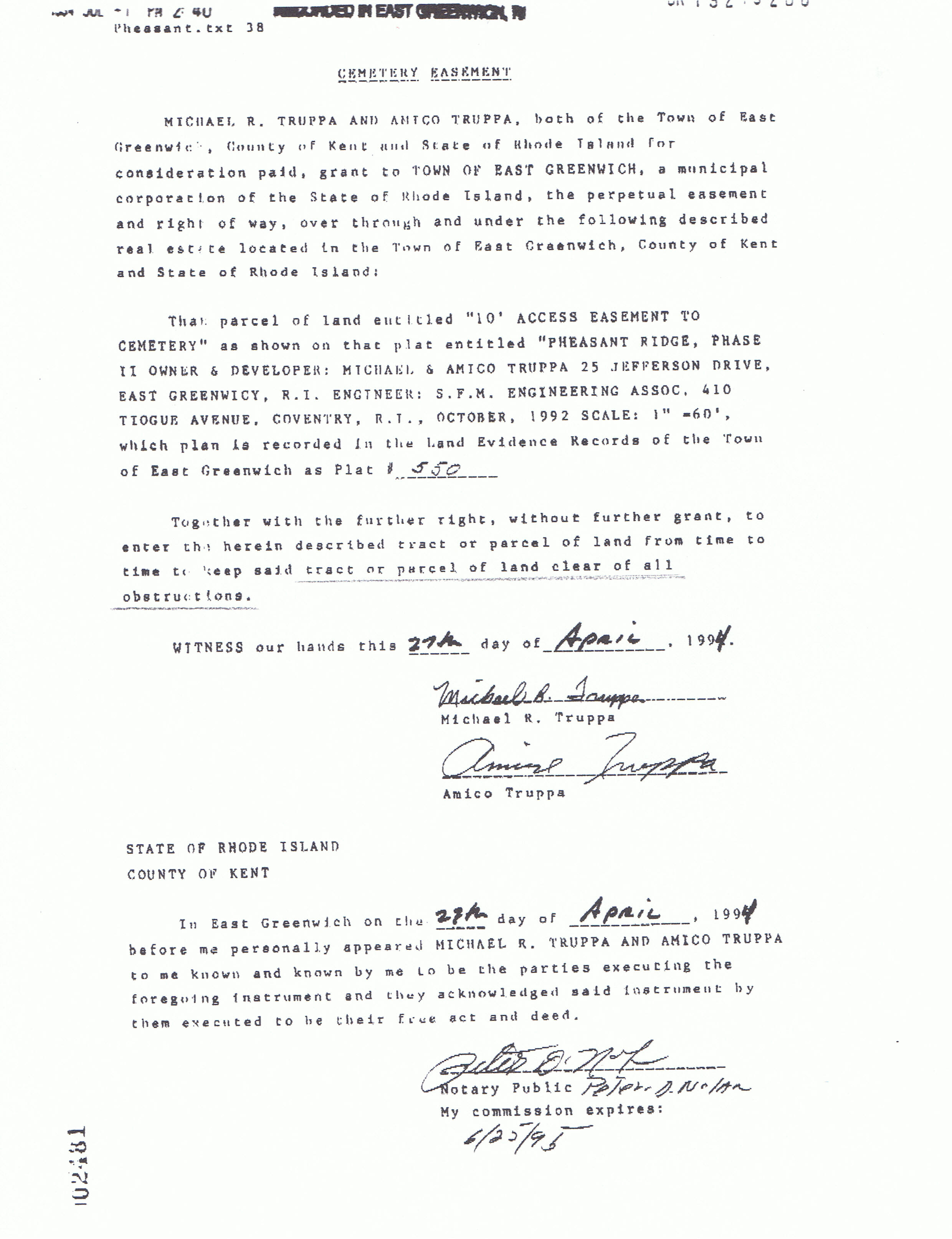
The following 1995 signed and notarized document from the Land Evidence Archives states that the 10 foot wide cemetery easement is to be kept free of obstructions, specially stated “to keep said tract or parcel of land clear of all obstructions”.
Cemetery Easement–Land Evidence Vault Archives–East Greenwich Town Hall–
Information from the land evidence archives:
Deed from Sweeney to J&D, 1987, transferred land excepting burial ground…together with a right-of-way by the cart path from Middle Road commencing at the break in the stone wall … to said burying ground over & upon said land to be conveyed.
1984 Planning Board decision re: Pheasant Ridge II; Condition #13: Homeowners Association shall be responsible for the primary maintenance of the historic cemetery located within Lot #11.
Land Evidence Book 192/Pg 280. Creates easement to the Town of East Greenwich…Together with the further right to enter the herein described tract or parcel to keep said tract or parcel of land clear of all obstructions.
 Land Evidence Vault–East Greenwich Town Hall–BK 119 Pg 663 |
 Land Evidence Vault–East Greenwich Town Hall–BK 119 Pg 664 |
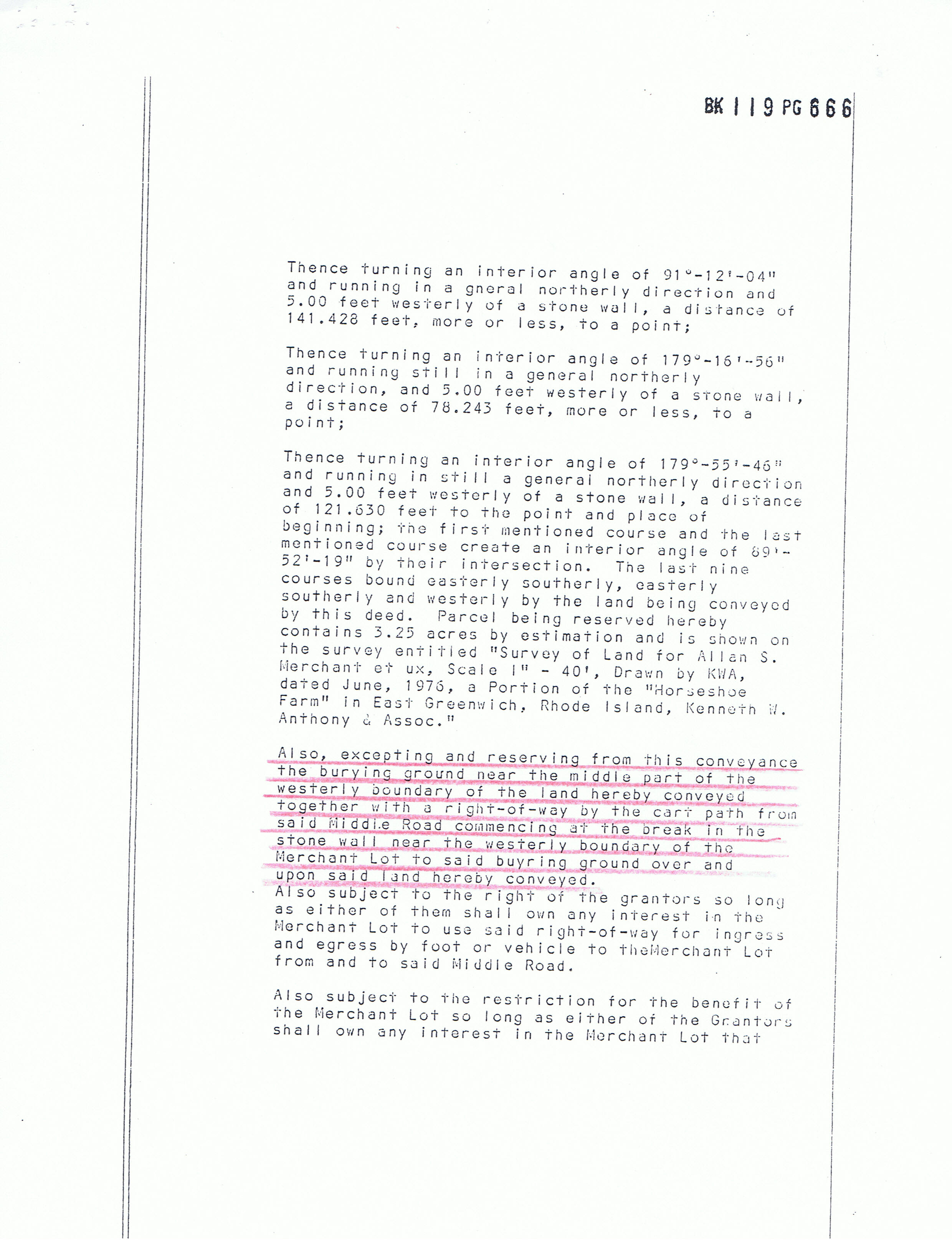 Land Evidence Vault–East Greenwich Town Hall–BK 119 Pg 666 |
 Land Evidence Vault–East Greenwich Town Hall–BK 119 Pg 667 |
The Merchant name mentioned above was the owners of the land before the development of the land in the last decade of the 20th century. Mrs. Allan Merchant, the elderly woman who was living in the house (the old Straight house and then the Spencer house) on 2266 Middle Road when the subdivision construction began, had the construction company sign that they would not disturb the old cemetery. This house at 2266 Middle Road is to the east of the Builder’s Survey map above; the Builder’s Survey map above is directly back–to the south as well as east–of the the Spencer Family Cemetery (East Greenwich historical cemetery #9) on Middle Road.
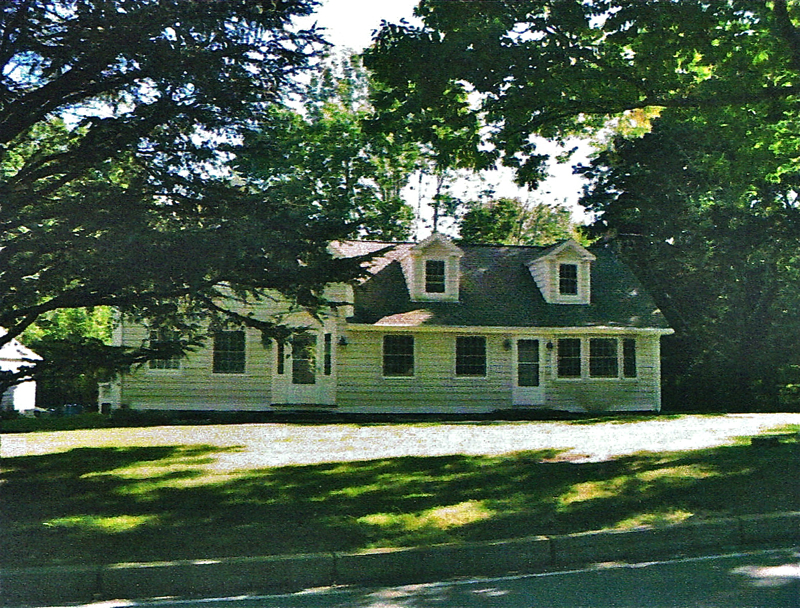
2010 photo, House at 2266 Middle Road, the original “old Straight house”, the Spencers moved the house down to Middle Road when Middle Road came through.
The above house on 2266 Middle Road shows no likeness to the original Straight house or to the farmhouse that the Spencers moved down to Middle Road, but none-the-less, the history of that house goes back to colonial times.
Rhode Island has more historical cemeteries than other states because of the separation church and state in colonial times. Burials were not in a church cemetery. Property owners had their own family cemetery on their own land. Therefore, if you know where your ancestors are buried, there is a good chance you also know where their land was and vice versa.